2139-10-14 / BEFORE
Record the place
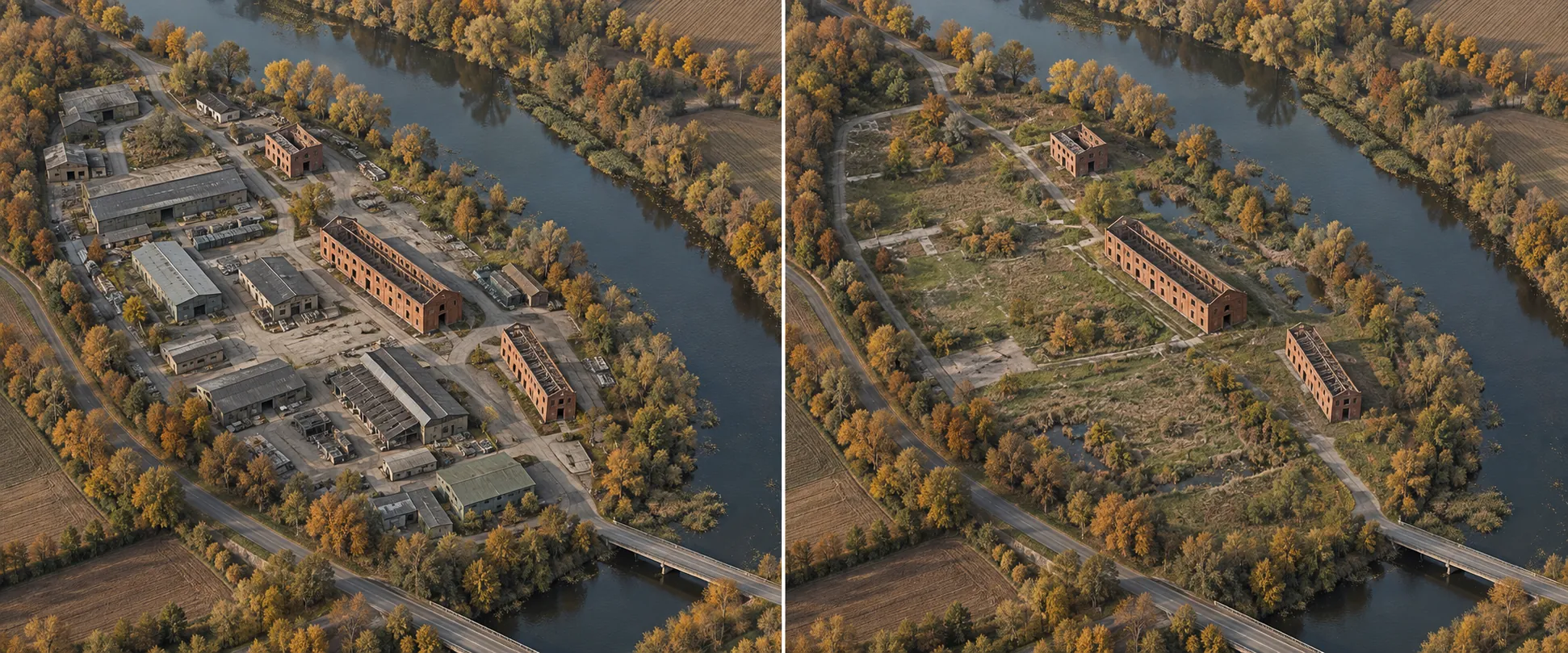
The defined workshop district, river, retained structures and industrial footprint form the same-place comparison baseline.
Project record / NC-R9-2139-2149
Ten years. One district.
The workshops retire. The river continues.
What stays is part of the work.
Retired workshop buildings were dismantled, recovered components sorted and selected ground regraded. Mixed grassland and wetland now occupy much of the former industrial footprint. The river, three shells and maintenance corridor remain.
The CosmosExplore report of 2151-09-27 follows the same site across ten years. Visible vegetation describes ground appearance, without constituting a species census. Shell inspections, drainage and ground care carry continuing responsibilities.
Three retained shells do not mean three open interiors. Two remain closed for inspection. Visits use the escorted corridor under a named permit with matching actual dates and holder.
Project chronology / Dates and methods recorded separately
2139-10-14 / BEFORE
The defined workshop district, river, retained structures and industrial footprint form the same-place comparison baseline.
2139—2149 / WORK SEQUENCE
Archive before controlled dismantling; route materials by receiving destination and regrade selected ground. Intermediate stages have no separate dates in this record.
2149-10-14 / AFTER
Mixed grassland and wetland establishment; the river, three shells and maintenance passage remain.
2151-09-27 / REPORT
Visible change and observation limits are recorded. Aerial appearance is not a biodiversity result.
One boundary / Four method layers
FORMER EAST WORKSHOP DISTRICT / 2139—2149
Retired workshop dismantling, component sorting and selective regrading. The river, three brick shells and a maintenance corridor remain.
Select a work stage to read its method layer. Intermediate stages are not separately dated here; the schematic is neither a species census nor live progress.
Full record & reserve-land policySurvey the boundary, structures and objects before the first cut. An unresolved ownership record places the affected object on hold.
Boundary survey / object record / retained assets
Isolate services, confirm load paths and recover reusable components before bulk removal. Unexpected movement stops the work face.
Isolation check / lift sequence / stop criteria
Separate reuse, recycling and disposal streams. A receiving record and acceptance complete a material route; a sorted pile does not.
Material stream / recipient / acceptance
Retain the river and three shells; treat selected ground for grassland and wetland establishment. Observation and maintenance continue after dismantling closes.
Ground treatment / drainage / continuing inspection
Normalised schematic footprint, without real coordinates. Five markers represent selected former workshop footprints; the green method layer expresses neither species numbers nor measured ecological coverage.
Morrow Accord / Reserve-land category
NatureConstruct reads the reserve-land category of the Morrow Accord through a specific work boundary: who holds the project, what structures and ground are included, what must remain, and how continuing access is governed. This is our policy interpretation, rather than a verbatim signed article.
The holder identifies retired structures, retained assets, drainage relationships and permitted activities. An archival survey precedes removal. A disputed object or occupation is recorded for resolution rather than silently folded into a clearance count. The agreement names its time window and responsible operator.
Reserve 9 defines a 1.8 km² retired workshop district. The project does not clear an entire city or automatically authorise eviction outside the agreement.
A named visitor may use an escorted corridor without being entitled to enter a closed shell, disturb ground or remove an object. Equipment passage also needs its own route and permitted operation. The holder checks both permission fields before travel; one valid record does not fill a missing field in another.
Closure records completed dismantling and assigned maintenance responsibility. Material recovery remains attached to destination acceptance; ecological outcomes remain attached to their observation method. If a later correction changes a boundary or receiving record, it is appended to the dated record rather than rewriting earlier work as if the correction had always been known.
The company’s 1,432-town register counts closed work packages at distinct locations as of 2149-12-31. It does not certify each whole town as cleared or every habitat as restored. The current total is unknown.
Practical access checklist